Odaesan National Park (오대산국립공원)

stocking
Gangwondo
0
79
0
0
2023.03.05 15:59
GANGWON-DO WEATHER
 > Korea Tourist Attractions http://stockzero.net/bbs/board.php?bo_table=tp_kr_attract&wr_id=766")
|
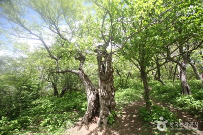
Odaesan Mountain is located in the central and eastern part of Gangwon-do. The mountain was designated a national park in February 1975, including an area of 298.5 ㎢ centered on the highest peak, Birobong Peak (alt. 1,563 meters). Other peaks include Horyeongbong, Sangwangbong, Dongdaesan, and Durobong.
Odaesan Mountain has the largest natural forest of Korea, home to many wild animals and plants. The mountain is divided into smaller sections: Odaesan Section, Bangadari Bridge Section, Byeongnae-ri Section, Hwangbyeongsan Mountain Section, Hongcheon-myeon Section, and Sogeumgang River Section. It is also rich in soil and resources, with lush forests and gentle slopes. |
|||||||
| Day off | Subject to abrupt closure due to adverse weather conditions | Opening day | |||||
|---|---|---|---|---|---|---|---|
| Experience guide | Age of use | ||||||
| Hours of use | Ask |
• 1330 Travel Hotline: +82-2-1330 (Korean, English, Japanese, Chinese) • For more info: +82-33-332-6417 |
|||||
| Di sản | Receive | ||||||
| Parking lot | Available | When should you use it? | |||||
| Stroller rental | none | Pet | none | ||||
| Credit | Source | KOREA TOURISM ORGANIZATION | |||||
| Address | Odaesan-ro, Pyeongchang-gun, Gangwon-do | ||||||
STOCKZERO does not store any data regarding current location information. We simply use OpenStreet's source code to show it to our customers.
The location may not be accurate on PC.
By viewing your current location, you are deemed to have understood and agreed to this content.


Natural Preservation Areas (closed to public):Woljeongsa Temple Entrance area (excluding hiking trails; 1,000 ㎡): Until 2026
Jingogae Pass - Dongdaesan Mountain (excluding hiking trails; 30,000 ㎡): Until 2027
Jilmoineup Marsh (12,341 ㎡): Until 2027
Sohwangbyeongsanneup Marsh (2,300 ㎡): Until 2027
Jogaedongneup Marsh (7,760 ㎡): Until 2028
Eulsugol Upper section & Valley section: Until 2034
Dongdaesan area: Until 2034 Night-time Hike Restriction Notice:To protect the environment and ensure the safety of hikers, hiking is prohibited at night (from sunset until two hours before sunrise). Areas Open to the Public:Sangwonsa Temple - Jeokmyeolbogung (2 km)
Sangwonsa Temple - Jungdae (1.3 km)
Sogeumgang River - Guryongpokpo Falls (2.5 km)
Woljeongsa Hoesa Street - Dongpigol Valley - Sangwonsa Temple (8.1 km) Hiking Course:Durobong Peak Course (10 km / 4hr 40 min ~ 5 hr)
Dongdaesan Mountain Course (4.4 km / 2 hr 10 min ~ 2 hr 30 min)
Sangwangbong Peak Course (14 km / 5 hr 20 min ~ 6 hr)
Sogeumgang River Course (13.3 km / 7 hr ~ 8 hr)
Birobong Peak Course (7 km / 3 hr 10 min ~ 3 hr 30 min)
Seonjae-gil Course (10 km / 3 hr 30 min)
Gyebangsan Mountain Course 1 (8.9 km / 6 hr)
Gyebangsan Mountain Course 2 (8.9 km / 6 hr) Mountain Not Access Period:Seasonal Forest Fire Watch by Park
Spring: February 15 - May 15 / Fall: November 1 - December 15
* TBD by park rangers based on weather advisories, snow/precipitation levels, and other local conditions. Visit the official website to check before visiting. Restricted Mountain Areas :Refer to the official website Restrooms:Available Admission Fees:Admission fees apply to Woljeongsa Temple Parking Fees:Light-weight car (under 1,000cc) 2,000 won
Mid-sized car / Small-sized car 4,000 won (Peak season 5,000 won)
Large-sized car 6,000 won (Peak season 7,500 won)
* Based on one day / one parking slot
* Jingogae Parking Lot has no parking fees as the parking lot is a subsidiary facility of the service station. Available Facilities:Campground, auto campground, visitor's center, etc.


